Deadly West Java landslide kills at least 25, dozens still missing
At least 25 people have been killed after a landslide and flash floods struck a hillside community in West Java, Indonesia, on 24 January 2026, following prolonged heavy rain. Dozens remain missing as rescue operations continue.

- A landslide and flash floods in West Java killed at least 25 people, with 65 still missing as of 25 January 2026.
- Prolonged heavy rainfall triggered slope failure and a sudden debris flow that devastated residential areas.
- Experts warn of ongoing risks, citing geological vulnerability, land-use change, and potential upstream blockages.
A deadly landslide and accompanying flash floods struck a hillside community in Indonesia’s West Java province in the early hours of Saturday, 24 January 2026, killing at least 25 people and leaving dozens more unaccounted for, as rescue teams race against time amid continuing risks of further ground movement.
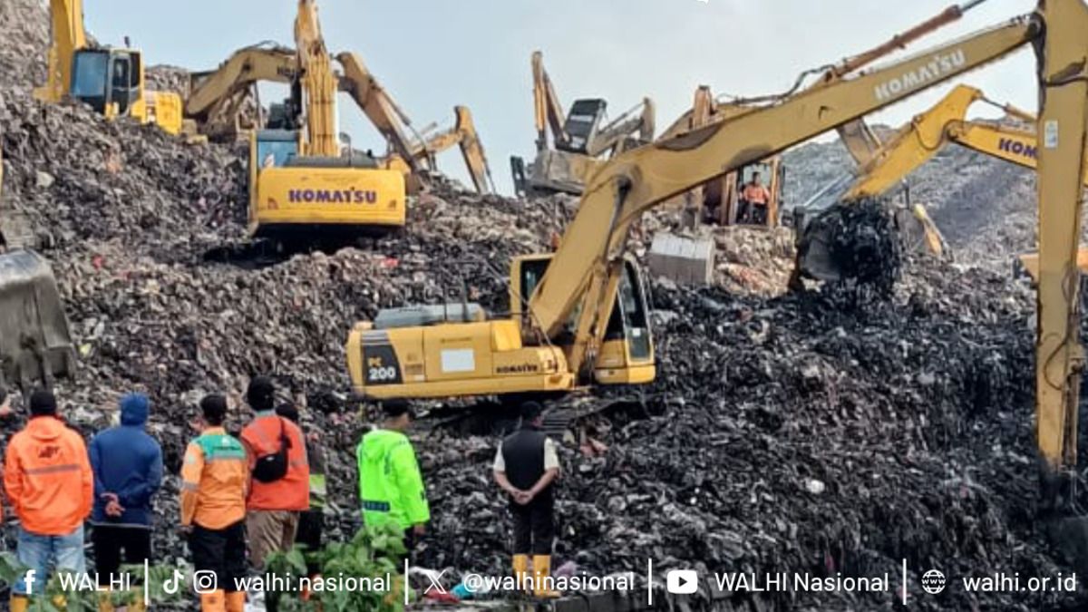
The disaster hit Kampung Babakan Cibudah in Pasirlangu Village, Cisarua Subdistrict, part of West Bandung Regency, after prolonged heavy rainfall drenched the area from Friday afternoon into the night. At around 3.00 a.m. local time, saturated slopes gave way, sending mud, rocks, and debris cascading through residential areas and along river channels, destroying homes and cutting off access roads.
Casualties and Missing Persons
The Cimahi Police Chief, Niko Nurullah Adi Putra, said initial reports indicated at least 10 fatalities shortly after the incident. By the second day of search and rescue operations, the confirmed death toll had risen sharply.
Senior Commissioner Hendra Rochmawan, Head of Public Relations at the West Java Regional Police, told reporters that 25 bodies had been recovered by Sunday, 25 January. Of these, 11 victims had been formally identified, while the remainder were undergoing forensic examination at the Disaster Victim Identification (DVI) post operated by the West Java Regional Police.
Official data show that 113 people were directly affected by the disaster. Twenty-three survivors have been found alive, leaving 65 people still missing as of Sunday evening.
Emergency Status and Displacement
The West Java Provincial Government has declared an Emergency Response Status starting on 23 January for a period of 14 days. Authorities have established an emergency command post, temporary shelters, and secured evacuation routes to reduce the risk posed by possible secondary landslides.
According to the West Java Provincial Disaster Management Agency (BPBD), approximately 30 houses across two neighbourhood units were buried in Pasirlangu Village. By Sunday, the evacuation centre at the Pasirlangu Village Office was hosting 680 displaced residents.
The number of evacuees has continued to rise as anxiety spreads among nearby communities. Residents from RW 12, located close to the disaster zone, also chose to evacuate despite their homes not being directly damaged, citing fears of further slope failures.
Urbanisation and Agricultural Expansion Under Scrutiny
Indonesia’s Minister of Environment, Hanif Faisol Nurofiq, suggested that the disaster may be linked to broader patterns of land-use change driven by urbanisation. He pointed to the expansion of intensive agriculture into hilly and forested areas as a contributing factor.
According to Hanif, rapid urban growth has altered dietary preferences, increasing demand for vegetables such as potatoes, cabbage, and capsicum—crops that typically grow at elevations between 800 and 2,000 metres above sea level. This demand, he said, has pushed farming activities uphill into environmentally sensitive zones.
“Our natural character is not like this,” Hanif said, as quoted by the Antara News Agency. “In 2025, this was not yet so massive. This has resulted in agriculture moving uphill and opening land in this way.”
Geological Vulnerability
The Geological Agency classified Pasirlangu Village as lying within a zone of moderate landslide susceptibility. Acting Head of the agency, Lana Saria, explained that ground movement is more likely in areas where slopes have been disturbed by human activity, particularly during prolonged heavy rainfall.
“The characteristics of weathered old volcanic rock and the presence of geological structures significantly increase this area’s vulnerability,” Lana said in a written statement. She added that dense settlements, slope cutting for housing and road access, and inadequate surface drainage had further weakened slope stability.
A Landslide Dam and Sudden Collapse
Offering a more nuanced explanation, Geology expert at the Bandung Institute of Technology (ITB), Imam Achmad Sadisu cautioned against attributing the disaster solely to land-use conversion. He said the most destructive force came not from a slope failure directly beneath homes, but from material released upstream.
According to Imam, a landslide in the upper reaches of the southern slopes of Mount Burangrang formed a temporary natural dam in the river channel. Water accumulated behind this blockage until it collapsed suddenly, unleashing a high-speed flow of mud, sand, and boulders downstream.
“Houses were not swept away by landslides occurring on the slopes where they stood,” Imam said in Bandung, “but were impacted by landslide material transported from upstream through the river channels.”
Ongoing Risks and Calls for Vigilance
Experts warn that the danger has not yet passed. Survey teams have identified signs of similar blockages further upstream, raising concerns that renewed heavy rainfall could trigger additional debris flows.
Imam urged residents living along riverbanks to pay close attention to warning signs during heavy rain. “If a river that usually flows suddenly recedes or disappears, this indicates an upstream blockage,” he said. “People should immediately move away from the river channel because water and debris can arrive without warning.”
He stressed that future disaster mitigation must go beyond reforestation, calling for structural measures such as debris-flow barriers, sediment control systems, and real-time monitoring using geophones or vibration sensors.
“What causes the greatest damage is not the water itself,” Imam concluded, “but the sediment material carried by the flow.”