Indonesia details Mount Merapi eruption activity after earthquakes shake Yogyakarta region
Yogyakarta experienced an unusual sequence of two earthquakes followed by pyroclastic flows from Mount Merapi on 27 January 2026, prompting heightened monitoring despite no reported casualties or damage.

- Two tectonic earthquakes struck the Yogyakarta region on 27 January 2026, followed hours later by pyroclastic flows from Mount Merapi.
- Authorities reported no casualties or damage, but intensified monitoring due to the region’s high geological risk.
- Experts are examining whether the earthquakes and volcanic activity are linked, while urging public vigilance.
Indonesia’s Ministry of Energy and Mineral Resources has issued a detailed briefing on the latest activity of Mount Merapi, following a day in which Yogyakarta was shaken by two earthquakes and later saw pyroclastic flows descend from the volcano’s summit.
In a press statement delivered on Thursday morning, 28 January, Eko Budi Lelono, Head of the Geological Agency at the Ministry of Energy and Mineral Resources (ESDM), presented the results of continuous monitoring conducted by the Centre for Volcanology and Geological Hazard Mitigation (BPPTKG).
The ministry’s statement came a day after Mount Merapi released pyroclastic flows on Tuesday afternoon, 27 January, just hours after a shallow earthquake struck the Bantul area and was felt widely across the Special Region of Yogyakarta.
Ministry confirms sustained high activity
According to Eko, BPPTKG monitoring recorded 52 pyroclastic density currents (block-and-ash flows) at Mount Merapi on 27 January, with a maximum run-out distance of up to three kilometres towards the south-west. The flows were concentrated along the upper reaches of the Boyong and Krasak rivers—areas that have long been identified as primary hazard channels.
“Ashfall was also reported in several locations,” Eko said, adding that this was a normal phenomenon, as fine eruptive material can be transported by wind over considerable distances.
While the ministry’s data reflect cumulative monitoring of Merapi’s eruptive behaviour, Eko stressed that the current activity remains within the officially designated hazard zones, which extend up to five kilometres from the summit.
Context: a volcano in an eruptive phase
The Geological Agency reiterated that Mount Merapi has been in a heightened state of activity for an extended period. Volcanic unrest has been increasing since late 2020, prompting authorities to raise the alert level from Waspada (Level II) to Siaga (Level III). Since entering an eruptive phase, Merapi has been characterised by effusive eruptions, marked by persistent incandescence around the lava dome area and frequent lava collapses.
“Mount Merapi has distinctive eruptive characteristics, known as the ‘Merapi-type’ eruption,” Eko said. “This involves the growth of a lava dome, followed by collapses that generate pyroclastic density currents.”
BPPTKG records show that, to date, 95 pyroclastic density currents have been documented during this eruptive phase, with the furthest reaching three kilometres from the summit—still within the established danger radius.
As of Thursday, 28 January, Eko said Merapi’s activity remained high. Seismic data continue to be dominated by signals associated with collapse activity, while deformation measurements from electronic distance measurement (EDM) instruments indicate relatively stable deformation rates.
Earthquakes earlier in the day
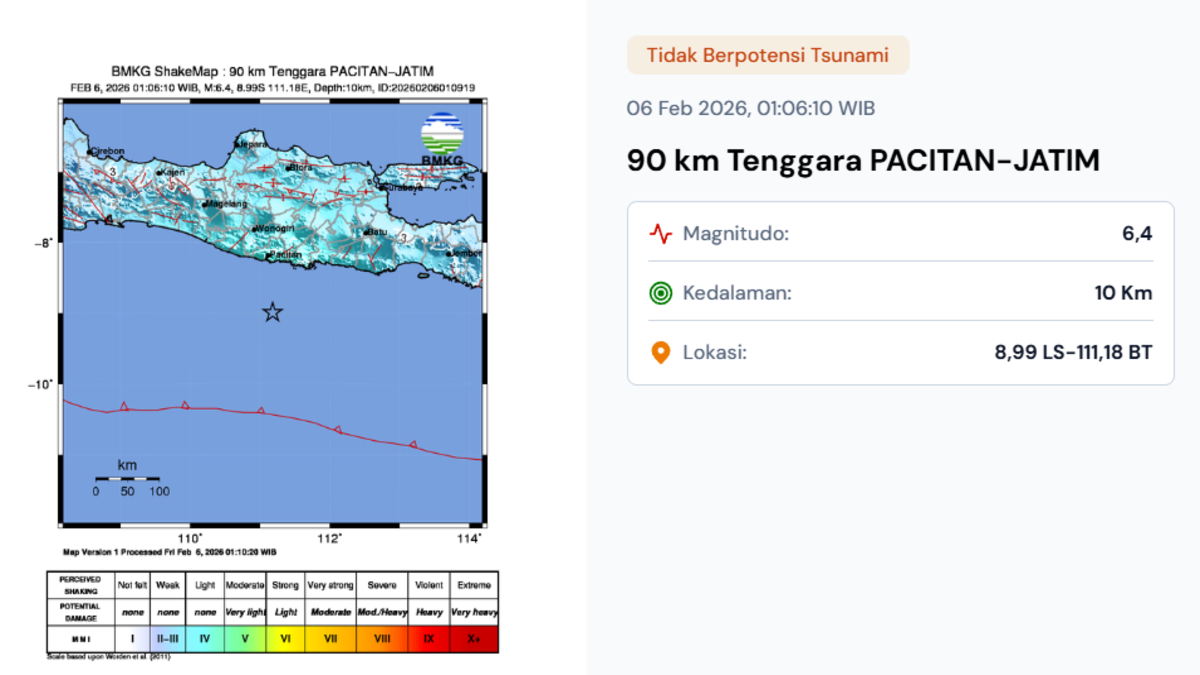
The ministry’s briefing followed a sequence of seismic events earlier on Tuesday. At 8:20 a.m. local time, a magnitude-5.5 earthquake off the coast near Pacitan in East Java was felt across large parts of Java and Bali. This was followed at 1:15 p.m. by a shallower magnitude-4.4–4.5 earthquake centred around 16 kilometres east of Bantul Regency.
Indonesia’s Meteorology, Climatology and Geophysics Agency (BMKG) said the afternoon quake was triggered by activity along the Opak Fault and was felt at intensity III on the Modified Mercalli Intensity scale in Bantul, Yogyakarta City, Sleman, Gunung Kidul, Kulon Progo and Klaten. BMKG later recorded 14 aftershocks, the strongest measuring magnitude 2.0.
BPPTKG personnel at the Babadan Observation Post in Magelang reported no immediate spike in volcanic seismicity following the earthquakes. Nevertheless, the appearance of pyroclastic flows several hours later has prompted further analysis into whether heavy rainfall, gravity-driven dome instability, or cumulative geological stress played a role.
Public warnings and mitigation measures
In its press release, the Ministry of Energy and Mineral Resources emphasised that BPPTKG continues to carry out hazard mitigation through round-the-clock monitoring, hazard assessment, public information dissemination, and community outreach.
The public has been urged to stay outside designated danger zones, remain alert to the risk of lahars during heavy rainfall, and follow updates issued by BPPTKG, local governments, and regional disaster management agencies (BPBD).
Yogyakarta sits at the intersection of active tectonic faults and one of Indonesia’s most dangerous volcanoes. While the earthquakes and Merapi’s activity are not unusual in isolation, the ministry said the events underscore the importance of preparedness and adherence to official guidance.