Mount Semeru’s eruption prompts mass evacuation; climbers stranded but safe
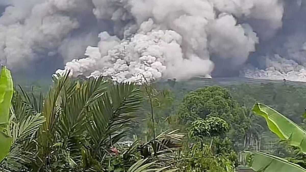
Mount Semeru erupted on 19 Nov 2025—ash columns soared ~2 000 m, pyroclastic flows reached ~7 km, more than 300 residents and 170 climbers rescued, alert level raised to highest and evacuation underway across East Java.
- East Java’s Mount Semeru erupted multiple times, causing authorities to raise its alert level to the highest (IV).
- Around 900 people have been evacuated, and 178 climbers who were stranded at Ranu Kumbolo are now being evacuated, with all reported safe.
- Some 300 local residents in Lumajang’s vulnerable villages have been relocated to shelters due to ash fall, and officials warn of further danger from lahar and pyroclastic flows.
On 19 November 2025 at approximately 16:00 local time, Mount Semeru—Java’s highest volcanic peak at 3,676 metres—erupted, sending an ash and pyroclastic cloud vertically and across its slopes.
The Indonesian Geological Agency raised the volcano’s status from Level III to Level IV (Awas/Warning) responding to high-activity readings and recurrent eruption sequences. Observers reported thick grey ash rising around 2 000 metres above the summit and flows reaching as far as 7 km down slope.
Videos circulating on social media show dense ash clouds sweeping over valleys and bridges near the affected area, underscoring the rapidly evolving hazard.
With aviation concerns raised—including alerts by the Australian Volcanic Ash Advisory Centre—the broader region faced disruption beyond the immediate danger zone.
Evacuations and those caught in the eruption
Local authorities report that more than 300 residents from villages in Lumajang district had been evacuated to safer locations such as schools or mosques.
Among the most challenging situations was a group of 178 climbers – comprised of guides, porters and tourists—who were camping at Ranu Kumbolo, about 6.4 km from the crater, when the eruption occurred. They were reported safe and in the process of descending to lower posts with assistance from search-and-rescue teams.
Rescue and disaster-management teams remain active in the field, monitoring for trapped persons and coordinating evacuations along river valleys prone to volcanic hazards.
Scope of volcanic hazards and geography
Mount Semeru’s eruption produced multiple hazard vectors:
-
Pyroclastic flows and avalanches: Hot ash, gas and rock that raced down slopes, up to 7 km from the summit (in earlier releases estimates reached 13 km).
-
Ashfall: Columns reaching ~2 000 metres above the summit, moving northward/north-westward, engulfing villages, farmland and transport routes.
-
Lahar and river-valley threats: Heavy rain in the region increases the risk of lahar (volcanic mudflows) especially along river basins such as Besuk Kobokan. The Geology Agency advised avoiding areas within ~8 km of the crater radius and ~500 metres from riverbanks in danger zones.
The topography around Semeru, with steep slopes, river valleys and close-in settlements, amplifies the risk. The eruption’s timing in the afternoon and subsequent weather conditions added complexity to rescue and monitoring efforts.
Response by authorities and safety measures
The Indonesian National Disaster Mitigation Agency (BNPB) and local Lumajang authorities activated emergency command posts and shelters. Residents were urged to wear masks or mouth coverings to reduce respiratory exposure to volcanic ash.
The Geology Agency instructed all activities to cease within 8 km from the summit, especially in the western to northeast sector. Riverbank exclusion zones were specified to limit exposure to lahar-prone areas.
Climber and tourist monitoring was intensified; Ranu Kumbolo evacuation was prioritized given its elevation (~2 400 m) and proximity to the hazard zone.
Authorities also coordinated with aviation agencies and local governments to manage air-space advisories and transport disruptions.
Local-news details and chronology
According to Indonesian media, by 14:13 WIB on 19 November the eruption sequence had begun, with repeated avalanche-type flows observed until 18:11 WIB; amplitude of seismic readings reached 40 mm.
Frequent ‘guguran’ (rock-fall) and lava-flow events had already been monitored in the days leading to the main eruption. Local village authorities in Supiturang, Oro-Oro Ombo and Penanggal reported ash accumulation and disrupted power and communications in early evening. Shelters filled with evacuees from these villages.
Wider implications and challenges
The eruption serves as a reminder of the ongoing volcanic risk in Indonesia, located on the Pacific “Ring of Fire”. Mount Semeru’s previous major eruption (December 2021) caused dozens of deaths and significant displacement. Key challenges now include:
-
Sustained support for evacuees, especially those from remote settlements and affected agricultural areas
-
Monitoring for secondary hazards, such as lahars during rain, and ash-fall health impacts
-
Climber and tourism-region safety, balancing access to natural attractions with hazard awareness and timely rescue capacity
-
Infrastructure resilience, e.g., road, power and communications networks affected by ash and flows
-
Inter-agency coordination, including geology agencies, local disaster management, forestry and tourism sectors
Outlook
Authorities say they will maintain Level IV alert for the foreseeable future, pending clearer signs of volcanic stabilisation. Local governments are allocating emergency funds for shelter, medical care and ash-cleanup efforts.
There may also be aerial and satellite ash-advisories for regional transport and aviation. Media and rescue teams continue to monitor video footage from social-media posts, which are providing real-time visuals of flows and ash movement.